
November 11, 2026
Mobile Billboard Route Planning, Start to Finish
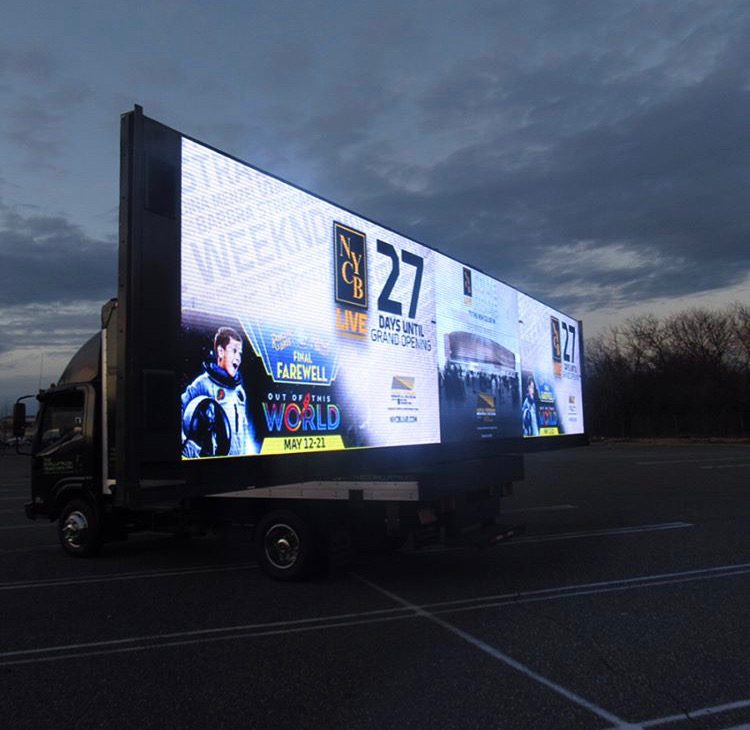
Mileage is the worst metric in this business and it is the one most route plans are built around.
A truck can cover a lot of ground and reach almost nobody. It can also sit still for forty minutes and reach more people than it did in the previous two hours of driving. If your route plan is a number of miles and a list of neighbourhoods, it is not a route plan. It is a driving itinerary.
Route planning is the part of a mobile billboard campaign that determines whether it works. The vehicle is a commodity. The screen or the panel is a commodity. The route is not, and it is the only part of the job where experience actually shows up in the result.
This page is how we build one. The survey work, the scoring, the dayparting grid, the loop arithmetic, the stationary positions, and all the ways it comes apart in the field.
I am going to be blunt about the stuff that does not work, because route plans tend to be sold with maps that look impressive and perform badly.
The core idea: you are buying dwell time, not distance
Here is the thing to hold onto through everything that follows.
The value of a mobile billboard is produced in the seconds a person spends with it in view. That is it. Everything we do in route planning is an attempt to manufacture more of those seconds.
Driving fast produces very few of them. A vehicle at highway speed passes a given observer in under a second, and that observer is facing forward in a lane they cannot leave, thinking about their exit.
Driving slowly through pedestrians produces a lot of them. A vehicle crawling down a retail street at fifteen miles an hour is in a walking person’s field of view for ten seconds or more, and they are already in scanning mode because they are looking at storefronts.
Sitting still beside a queue produces enormous amounts of them. A parked vehicle beside a line of people waiting to get into a venue is in view for as long as that line takes to move.
Once you internalise that, most route decisions answer themselves. Avoid the highway. Favour congestion over flow. Build in stationary blocks. Keep loops tight enough that repeat exposure happens.
Step one: the survey
We do not plan from a desk map. Desk maps lie about three things that matter enormously: how slow traffic actually is, how many people are actually on the sidewalk, and whether the vehicle physically fits.
The survey has three passes.
Daylight drive. Someone drives the candidate corridors in a vehicle of comparable size. We are checking clearances, turn radii, one way patterns, bus lanes, bike lanes that narrow the roadway, construction, and whether there are height restricted underpasses on any connecting leg. A route that requires a three point turn in a busy intersection is not a route.
Pedestrian count pass. On foot, at the hours the campaign will run. This is not scientific and I will not pretend it is. It is a trained person standing on a corner for a while, at 8am, at 1pm, at 6pm, at 10pm, noting how many people are moving and which way they face. The difference between a street that looks busy on a weekday lunch and a street that is genuinely busy at 9pm is invisible on any map.
Signal and congestion pass. We drive the loop and count. How many signalised stops. How long they hold. Where traffic naturally backs up. Where it flows freely, which is a negative, not a positive.
That third one produces the number I care most about: stops per loop.
Step two: scoring corridors
Every candidate corridor gets judged on the same things. There is no magic formula, and anyone who shows you one with weights and decimal points is dressing up a judgement call.
Pedestrian density at the relevant hours. Not average. At the hours you will be there.
Signal density. Stops per mile. More is better. Every red light is a free pause with your message in somebody’s windscreen.
Speed profile. Slower is better. A corridor with a posted limit of twenty five that actually moves at twelve in the evening is excellent.
Sightline quality. Can people actually see the vehicle’s flank? A street with a row of parked cars and street trees between the traffic lane and the sidewalk hides your panel from pedestrians. Wide sidewalks, open plazas and multi lane roads where your flank is visible across lanes are better.
Sun angle. For LED, direct low sun on the screen is a dead stretch. For printed panels, it matters less. Which direction a corridor runs, and at what hour, changes its value.
Access and legality of lingering. Can the vehicle stop anywhere here, or is it a continuous no stopping stretch?
Audience fit. Obvious, but worth saying. A busy corridor full of the wrong people is a busy corridor full of the wrong people.
Sensitivity. Residential, school zones, hospital frontage, places where a large advertising vehicle creates friction rather than attention. We mark these and route around them or restrict hours.
Corridors get sorted into primary, secondary and connector. Primary is where the campaign actually happens. Secondary fills gaps and provides alternates. Connectors are the legs we have to drive to get between primaries, and we keep them short because they are dead time.
Step three: the dayparting grid
This is where plans separate themselves from itineraries.
We build a grid. Hours down one side, zones across the top, and we fill in where the audience is in each block. The grid for a campaign aimed at commuters looks nothing like the grid for a campaign aimed at a nightlife audience, even in the same city.
Rough shape of a weekday for most urban campaigns:
Early morning. Commuter inbound corridors, transit hubs, parking approach routes. Short window, high density, worth hitting hard if your audience commutes.
Mid morning. Generally weak. Low pedestrian volume, free flowing traffic. This is the block most itineraries waste driving a big loop for nothing. We either idle the vehicle, use it for repositioning, or schedule it against a specific daytime audience like a hospital campus, a courthouse district or a wholesale area where mid morning is actually the peak.
Lunch. Strong in central business districts and retail. Dense foot traffic, slow streets, people in scanning mode. Short and high value. Stationary positions matter here.
Afternoon. Variable. Retail corridors pick up, school pickup zones get busy and are usually a sensitivity we avoid rather than a target.
Evening commute. Outbound corridors, heavy congestion. High dwell per observer because people sit in it, but the same observers repeatedly if you are not careful.
Evening and night. Restaurant and bar districts, venues, event let out. Often the single best block for an LED rig because the screen is at its most visually dominant and the audience is unhurried and social.
Late night. Diminishing, and the residential sensitivity gets sharper. We tend to cut.
Weekends invert most of this. No commute, later start, stronger midday retail, longer evening.
The grid is the deliverable I want a client to look at, not the map.
Step four: loop arithmetic
Once zones and hours are set, we work out loop length, and this is the piece that is most often wrong.
The question is simple: how often do you want the same person to see the vehicle?
For a broad awareness campaign across a city, repeat exposure to the same person is largely wasted. You want wide coverage, long loops, minimal overlap.
For a saturation campaign in a defined district, repeat exposure is the entire point. You want someone in that district for an evening to see the vehicle three or four times, because three or four passes is where recognition starts. That means a loop of roughly twenty to forty minutes, not ninety.
Most clients ask for a district saturation outcome and are handed a city wide itinerary. The loop is too long, each person sees it once, and the campaign under delivers while the mileage report looks fine.
Tightening a loop usually means accepting a smaller geographic footprint. That trade is the single most important conversation in route planning and it should be had explicitly, with the client, before anything is booked.
Two practical notes:
Loops should not be perfectly circular in behaviour. If you drive the identical path every time, the same parked observers see you and nobody else does. We vary direction and alternate between two or three near identical loops so coverage spreads while repeat frequency holds.
Loop time in the plan is optimistic. Real traffic adds to it. We plan loops shorter than the target so that reality lands on target.
Step five: stationary positions
The highest value minutes in most campaigns are not driving minutes and I will keep saying it.
A stationary position needs four things:
The fourth one is what makes a position great rather than fine. Queues outside venues. Transit stops. Plaza seating. Outdoor dining. Pickup zones where rideshare passengers wait. A crowd that is stationary and mildly bored is the best audience this format ever gets.
Finding these is a walking job, done at the hour it matters, and the list is campaign specific. A position that is superb at 10pm on a Saturday is an empty kerb at 10am on a Tuesday.
We confirm what is actually permitted in each spot, we use metered spaces properly where that is the arrangement, and where there is an opportunity to sit on private property with the owner’s permission, for example a lot beside a venue or a retail site, that is usually the strongest position available because the permission question is settled.
Permission, ordinance and the grey area
Mobile advertising sits in a grey area across the country and I will not give you a blanket ruling on where it stands in any particular city, because that is not a statement that holds and it would be advice I am not qualified to give.
What is true is that the picture varies by municipality and sometimes by district. Some cities have explicit provisions addressing advertising vehicles. Some restrict particular districts, particular hours, or stationary advertising display. Some have nothing specific and the question falls to general vehicle, parking or nuisance rules. Enforcement is inconsistent, and it is inconsistent in both directions: a route that runs untroubled for a week can draw attention on day eight.
How that shapes route planning in practice:
We research the local posture before committing. If a city or district has a restrictive reputation toward advertising vehicles, the route changes or the campaign does, and we raise it early rather than after you have committed.
Stationary positions get the most scrutiny. Driving through is rarely the friction point. Sitting still in an advertising vehicle is where rules tend to bite. We check what is permitted in each position rather than assuming the kerb is open.
We prefer private property with permission for extended stationary blocks. Owner permission turns a grey question into a settled one.
We avoid residential idling, particularly at night, particularly with a generator running. That is how campaigns collect complaints, and complaints are how a tolerant posture turns into an intolerant one.
We build alternates for every segment so that a position being unavailable, or being asked to move, costs us ten minutes rather than a shift.
We stop when asked. The driver does not debate at the kerbside. They move to the alternate.
We document the actual route driven, with timestamps and photographs, so there is a record of what happened rather than a recollection.
Check your own position with your own counsel for your own campaign. What I am describing is operational practice.
Weather, events and the things that break a plan
Rain does not hurt the vehicle. It empties the sidewalk, which is where your value is. A soaked evening in a nightlife district is a shift that should usually be moved rather than driven.
Low winter sun creates dead headings for LED screens at specific hours. Known in advance, routed around.
Heat is a hardware risk for LED rigs, a cooling and fuel issue, and a reason to check the vehicle more often rather than a reason to change the route.
Snow is a routing problem. Narrow streets narrow further, kerbside stationary positions disappear under snow banks, and a big vehicle becomes a hazard in tight districts.
Events cut both ways. A festival or a game is an enormous opportunity and a routing nightmare simultaneously, because the closures that create the crowd also block your access to it. Event routing is planned separately, with positions established before the closures go in and an exit strategy for after.
Construction and filming close streets with little notice. This is why the alternates exist.
What goes wrong, and what we talk clients out of
“Cover the whole city.” A single vehicle covering a whole city covers none of it meaningfully. We would rather own three corridors than visit thirty.
“Maximise miles.” Mileage is a cost, not an outcome. A plan optimised for mileage drives connectors and highways, which is the worst possible use of the hours.
“Run it on the interstate.” Looks great on a route map. Delivers almost nothing, and lingering in traffic lanes is neither safe nor sensible.
“Start at 9am and finish at 5pm.” A flat office day ignores the actual rhythm of a street. We would rather run a split shift that catches lunch and evening and idles the dead middle than burn fuel and hours driving an empty district.
“One day.” Frequency is the mechanism this format works through. A single day is a sliver, and if that is the whole budget, a different format usually serves better. We will say so.
“Park it outside their office.” No. We do not build routes targeting a named business’s doorstep.
“Just give us the GPS log as the report.” A GPS trail is proof of movement, not proof of value. The report that matters pairs the route with hours on screen, the stationary blocks actually achieved, photographs from the positions the brief asked for, and an honest note on which corridors underperformed so the next run is better.
The limitation worth naming: a mobile billboard is presence while present. When the shift ends, the street has nothing of yours on it. That is the trade against physical formats, and it is why I recommend pairing a route with Wheatpasting & Poster Campaigns in the same corridors the vehicle works. The route creates frequency and motion during the hours it runs. The posters hold those corridors overnight and between shifts. Running the route alone means buying reach that resets to zero at the end of every day.
What a finished route plan should contain
If an operator hands you a route plan, it should have all of this in it. If it has only a map, ask for the rest.
That is a plan. Everything short of it is a map with good intentions.
Frequently asked questions
What actually makes a mobile billboard route effective?
Dwell time, not distance. The route should favour slow moving corridors with frequent signalised stops, heavy pedestrian volume and clear sightlines to the vehicle flank, plus deliberate stationary blocks beside stationary crowds. Highways and free flowing arterials look impressive on a mileage report and deliver very little, because observers pass in under a second facing forward.
How long should a mobile billboard loop be?
It depends on whether you want coverage or saturation. Broad city awareness favours longer loops with minimal overlap, because repeat exposure to the same people is wasted. District saturation wants roughly twenty to forty minutes so someone in the area for an evening sees the vehicle three or four times. Tighter loops mean a smaller footprint, and that trade should be explicit.
Does a mobile billboard work better parked or driving?
Parked positions usually produce the highest value minutes, especially beside queues, transit stops, outdoor dining or plaza seating where people are stationary and unhurried. Driving loops spread reach across more distinct people. Strong campaigns combine both, with stationary blocks timed to when crowds gather and driving loops filling the hours between them.
How do you handle city rules on advertising vehicles?
Mobile advertising is a grey area that varies by municipality and sometimes by district, with inconsistent enforcement. We research the local posture before committing a route, give stationary positions the most scrutiny, favour private property with owner permission for long stops, avoid residential idling at night, build alternates and move when asked. Consult your own counsel for your campaign.
What hours should a mobile billboard campaign run?
Match the hours to the audience rather than an office day. Commuter corridors reward early morning and evening congestion, central districts peak at lunch, and restaurant, bar and venue districts are often the strongest block for an illuminated rig. Mid morning is usually weak, and deliberately idling through it beats burning hours driving an empty district.
What should a route report actually include?
More than a GPS trail, which only proves movement. A useful report pairs the route actually driven with hours the display was live, the stationary blocks genuinely achieved, timestamped photographs from the positions the brief specified, notes on closures or diversions, and an honest assessment of which corridors underperformed so the next run improves.
Request a campaign quote
Tell us the city, the audience, the dates and what you want to happen. We will come back with named corridors, a dayparting grid, stationary positions and the reasoning behind each one.
If the honest answer is that a route will not deliver what you want, we will tell you that too.
Request a campaign quote and we will build the plan around dwell time instead of mileage.

Ready to Run Your Campaign?
Call us or email us. We’ll tell you exactly what we can do in your market and what it costs.
Related Services
Explore similar advertising solutions offered by American Guerrilla Marketing.
American Guerrilla Marketing — Los Angeles
Street-level campaigns in Los Angeles and nationwide. Wheatpasting, LED trucks, street teams, and more.
(646) 776-2770
Related Articles
-
Planning LED Trucks & Mobile Billboards in Jacksonville
November 11, 2026
-
Planning LED Trucks & Mobile Billboards in Spokane
November 11, 2026
-
Planning LED Trucks & Mobile Billboards in Atlantic City
November 11, 2026
-
How Brand Ambassador Staffing Agencies Actually Deploy a
November 11, 2026
-
Digital Billboard Truck Rental: How It Actually Works
November 10, 2026